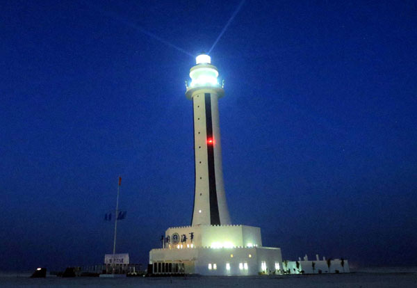
China has started the operations of a lighthouse in Subi Reef, The Chinese news agency Xinhua reported Tuesday.
Xinhua said the 55-meter high lighthouse contains technology to monitor passing ships.
The Philippines should be very concerned.
Subi Reef is the nearest China- occupied feature in the disputed Spratlys to the Philippine-occupied Pag-asa island. Only 12 nautical miles of the sea separate the two features claimed not only by China and the Philippines but also Vietnam.
Subi is Zamora Reef to the Philippines, Zhǔbì Jiāo to China and đá Xu Bi to Vietnam. Pag-asa is also known as Thitu, Zhōngyè Dǎo to China and Đảo Thị Tứ to Vietnam.
As warned by Magdalo Rep. Ashley Acedillo in May last year, the reclamations and construction of military facilities in Subi Reef and Mischief Reef are intended to choke off access to Ayungin shoal, where the Philippines maintains a military outpost in a rusty WWII warship beached there, the BRP Sierra Madre.
It was also near Subi Reef where the U.S. guided missile destroyer the USS Lassen sailed within 12 nautical miles October last year in its Freedom of Navigation assertion.
The lighthouse in Subi Reef is China’s third in Spratlys. The two others are in Huayang (Calderon Reef ) Reef and Chigua (Johnson South)Reef.
The Aquino government, which expects the decision of the United Nations Arbitral Tribunal on its case filed versus China on the latter’s nine-dashed line map, has not been reported to have filed a protest on China’s Subi Reef lighthouse.
It’s disturbing and infuriating. Philippine authorities knew about the construction of the lighthouse in Subi Reef as early as far back as 2010.
Here’s a report by VERA Files’ Tessa Jamandre titled “China builds lighthouse on PHL-claimed territory in Spratlys”:
“China has constructed a lighthouse on Subi Reef in the disputed areas in the South China Sea which Chinese troops are occupying but is being claimed by the Philippines and Vietnam.
“Aerial shots taken in October by the Philippine Air Force on routine reconnaissance flights show the 20-by-20-meter structure complemented by parabolic antennas and domes on the reef, which the Philippine government calls “Zamora” and lies only 26 kilometers southwest of Pag-asa that is part of Kalayaan town.
“The lighthouse is intended to expand and fortify China’s claim over the hotly contested Spratly group of islands, experts said.
“Under international law, a lighthouse is a recognized base point from where a state can measure its maritime regimes, including territorial sea (12 nautical miles from the baseline), contiguous zone (24 nm), economic exclusive zone (200 nm), continental shelf (200 nm) and extended continental shelf (350nm).
“Malacañang and the Department of Foreign Affairs declined to comment on the information when asked for their reaction. An official, who asked not to be named, said they would like to see first the published article.
““I think that should be resisted. That really goes against all understandings,” said former ambassador to Japan Domingo Siazon who was the foreign secretary in 1995 when the Philippines strongly protested the construction by China of military-type structures on Mischief Reef, 150 miles west of Palawan and 620 miles southeast of China.”
Malacanang and the DFA remained silent and did not protest after the publication of VERA Files’ article.
Is it any wonder that China proceeded with the construction without any trouble?
Be First to Comment